Earth’s largest iceberg has run aground off the coast of South Georgia Island, a common rendezvous spot for large icebergs, new satellite images show.
Measuring 1,240 square miles (3,460 square kilometers), the Antarctic iceberg A-23A has come to a grinding halt after a long and winding journey across the Scotia Sea, also known as “iceberg alley.”
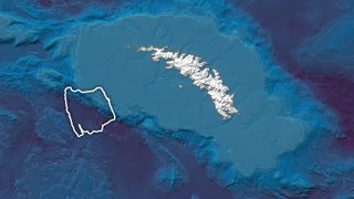
Satellite images taken at the beginning of March show the iceberg parked on a shallow underwater shelf off the coast of South Georgia Island, which is a British overseas territory in the South Atlantic Ocean and the largest of nine islands that make up the South Georgia and South Sandwich Islands.
The new images of A-23A were taken by the MODIS (Moderate Resolution Imaging Spectroradiometer) instrument on NASA’s Aqua satellite. Earlier observations suggest the iceberg’s northward drift slowed suddenly in late February, according to a statement from NASA’s Earth Observatory.
You may like
Related: Satellites watch world’s largest iceberg on crash course with Antarctic penguin island (photo/video)
“I think the big question now is whether the strong current will trap it there as it melts and breaks up or whether it will spin around to the south of the island like previous bergs,” Josh Willis, an oceanographer at NASA’s Jet Propulsion Laboratory in Southern California, said in the statement. “Time will tell.”
Ocean currents have carried other notable icebergs to this same region, including the trillion-ton A-68A, which was even bigger than A23A, measuring 2,200 square miles (5698 square km) at its largest. Initially stranded in December 2020, A-68A quickly broke into two main pieces that continued to fracture and eventually disintegrated over the course of three months, adding 152 billion metric tons of fresh water to the northern Scotia Sea around South Georgia.

RELATED STORIES:
A-23A has travelled more than 1,200 miles (2,000 km) north from its home in the Southern Weddell Sea, where it calved from Antarctica’s Filchner-Ronne Ice Shelf in 1986. After several decades, the iceberg broke away from the seafloor and began to drift in the early 2020s. Since stranding near South Georgia Island, several small ice fragments have already chipped away from A-23A, as seen in the new satellite images.
“When icebergs make it this far north, they eventually succumb to the warmer waters, winds and currents that make this ocean area a challenge for all seafarers,” NASA officials said in the statement.
While there is no permanent human population on the remote island, South Georgia supports abundant life, from seals and penguins to tiny phytoplankton. Fresh water melting from the bottom of the iceberg could affect the local ocean environment and flora and fauna along the island’s shoreline. Satellites will continue to monitor the iceberg and any ice fragments that break off into the ocean.