It’s summer in the Northern Hemisphere — and that means it’s fire season. Satellites are pitching in to monitor dozens of blazes nationwide.
The largest fire currently burning in the U.S. is the massive Bootleg Fire in south-central Oregon, which sparked on July 6 and currently covers more than 200,000 acres (800 square kilometers). More than 1,700 people are currently fighting the fire, which is only 5% contained, according to data from the National Wildfire Coordinating Group.
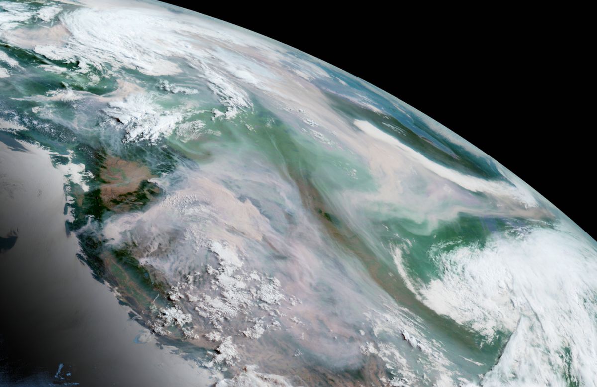
Since the Bootleg Fire began, satellites managed by the National Oceanic and Atmospheric Administration (NOAA) have been monitoring smoke pouring from the blaze and drifting across the country. Leading that effort is the GOES-17 satellite, which is stationed over the western half of the nation.
Related: Half the country is facing an apocalyptic summer
UPDATE: Oregon’s #BootlegFire showed explosive growth last evening, with its #smoke and #pyrocumulus clouds seen here by @NOAA’s #GOES17🛰️. This is the largest active fire burning in the U.S., and has spread to more than 212,000 acres at last report. #ORwx pic.twitter.com/YyQtbN3O2oJuly 15, 2021
Among other payloads, GOES-17 carries instruments that can detect heat, even that produced by small fires, as well as cameras that can image smoke, according to NOAA. The combined capabilities allow the satellite to identify new fires, monitor existing ones and watch for the floods and landslides that often follow in burned areas.
GOES-17 can also detect pyrocumulus clouds, nicknamed “fire clouds,” which structurally resemble thunder clouds but form when a fire kicks heat and moisture into the atmosphere, according to NASA.
#SATELLITE SPOTLIGHT: @NOAA’s #GOES17🛰️ is tracking the #smoke from several #wildfires across #Oregon this week, including the massive #BootlegFire seen here late yesterday. According to @inciweb, the fire has grown to more than 200,000 acres this morning. pic.twitter.com/MDx1Fjjp2aJuly 13, 2021
And aerosol instruments also provide information that forecasters use to estimate air quality and visibility, which can impact regions well beyond the flames.
Oregon is seeing unusually high levels of fire activity this year, considering that it is still relatively early in the season, according to Oregon Public Broadcasting. The state has struggled with drought and was baked by the so-called “heat dome” that stalled over the Pacific Northwest in late June.
Related: The top 10 views of Earth from space
#SATELLITE SPOTLIGHT: @NOAA’s #GOES17🛰️ is tracking a lot of #smoke from the numerous #wildfires burning across the western U.S. and Canada. #AirQuality Alerts are in effect for locations from California to Minnesota. More: https://t.co/8J0p5zRx2c pic.twitter.com/4pwUlTGDNTJuly 14, 2021
But Bootleg has plenty of company: According to NOAA, as of Wednesday (July 14), 68 active fires had burned more than 1 million acres (4,000 square km) nationwide.
The largest of those conflagrations, according to the National Wildfire Coordinating Group, are the Snake River Complex blazes in Idaho and the Beckwourth Complex blazes in California. Each of these fire complexes stem from one or more lightning strikes and has burned about 100,000 acres (400 square km) so far.
#SATELLITE SPOTLIGHT: As several #wildfires raged across the Pacific Northwest last evening, @NOAA’s #GOES17🛰️ was keeping an eye on the massive amount of smoke they produced. Seen here, Oregon’s #JackFire and #BootlegFire and Washington’s #LickCreekFire. #ORwx #WAwx pic.twitter.com/BiG07p0O5VJuly 14, 2021
NOAA data shared on Wednesday also depicts smoke from two other smaller fires, the Jack Fire in Oregon and the Lick Creek Fire in Washington.
The ongoing climate crisis makes wildfires more numerous and more severe, both by increasing temperatures and by decreasing moisture. Social factors, like building in unsafe areas and underpaying firefighters, are also worsening the impact of fires on humans.
Email Meghan Bartels at mbartels@space.com or follow her on Twitter @meghanbartels. Follow us on Twitter @Spacedotcom and on Facebook.


