
A NASA science instrument in orbit will form the backbone of a new initiative to survey methane emissions from landfills in a new nonprofit project to track the greenhouse gas.
The new project, led by the nonprofit group Carbon Mapper, will use data collected from the International Space Station by NASA’s EMIT experiment (its name is short for Earth Surface Mineral Dust Source Investigation) and other NASA science instruments to track methane, which according to NASA is the source of around a quarter to a third of human-driven global warming.
By establishing a baseline assessment of waste sites across the planet, and determining which sites emit methane at high rates, the initiative could help decision-makers reduce the concentration of the greenhouse gas in the atmosphere thus limiting climate change.
Related: 10 signs of climate change satellites see from space
“Currently, there is limited actionable information about methane emissions from the global waste sector,” Carbon Mapper CEO Riley Duren said in a NASA statement. “A comprehensive understanding of high-emission point sources from waste sites is a critical step to mitigating them.”
In comparison to carbon dioxide, methane is pound for pound 80 times more potent in trapping heat in the atmosphere. Unlike carbon dioxide, however, methane doesn’t last as long in Earth’s atmosphere and has a lifetime of decades rather than centuries. This means that significantly reducing methane emissions could have an immediate effect in slowing atmospheric warming.
As the waste sector is estimated to contribute around 20% of human-caused methane emissions it is one of the primary focuses of the mission to reduce this greenhouse gas.
“New technological capabilities that are making these emissions visible — and therefore actionable — have the potential to change the game, elevating our collective understanding of near-term opportunities in this often overlooked sector,” Duren said.
Related stories:
The Carbon Mapper project will conduct an initial remote-sensing survey of over 1,000 managed landfills across the United States, Canada, and other sites in Latin America, Africa, and Asia in 2023.
This data will be collected using aircraft-based sensors such as the Airborne Visible/Infrared Imaging Spectrometer-Next Generation (AVIRIS-NG (opens in new tab)) and Arizona State University’s Global Airborne Observatory both developed at NASA’s Jet Propulsion Laboratory (JPL) in Southern California.
The project will also use methane data from EMIT which was installed at the International Space Station in July with the purpose of the studying the mineral content of the planet’s major dust-producing regions.
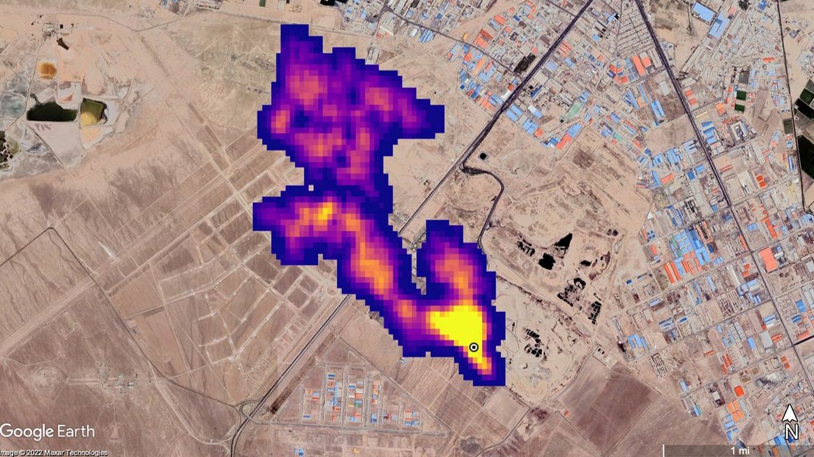
In October 2022, EMIT demonstrated its capability in methane detection, spotting methane plumes from over 50 so-called “super-emitters” in Central Asia, the Middle East and the Southwestern United States.
“NASA JPL has a decade-long track record of using airborne imaging spectrometers to make high-quality observations of methane point-source emissions,” Robert Green, the EMIT principal investigator at JPL, said in the NASA statement. “With EMIT we have employed the same technology in a spaceborne instrument, enabling us to collect information on localized methane sources from orbit.”
Following its first year, the Carbon Mapper team will begin a broader survey of around 10,000 landfill sites across the globe using satellites equipped with imaging spectrometer technology developed at JPL. These specially purposed Carbon Mapper spacecraft are set to launch in late 2023.
Follow us on Twitter @Spacedotcom or on Facebook.