5 min read Preparations for Next Moonwalk Simulations Underway (and Underwater) The best known use of GPS satellites is to help people know their location whether driving a car, navigating a ship or plane, or trekking across remote territory. Another important, but lesser-known, use is to distribute information to other Earth-viewing satellites to help them pinpoint measurements of our planet. NASA and several other federal agencies, including the U.S. Space Force, U.S. Space Command, the U.S. Naval Research Laboratory, and the National Geospatial-Intelligence Agency are improving the location accuracy of these…
Read MoreTag: Earth
Satellites watch as Japan’s new volcanic island continues to grow (image)
A new image taken from space shows that an island forged in volcanic fire on the Pacific Seas off Japan at the end of Oct. 2023 is still rising from the sea. The new volcanic island, which has been named Niijima — meaning “new island” in Japanese — was imaged by the European Space Agency’s (ESA’s) Copernicus Sentinel-2 satellite on Nov. 27. The continued growth of the island shows that the underwater volcanic activity that birthed the island off the southern coast of Iwo Jima is continuing. The University of…
Read MoreA ‘runaway star’ could save Earth from extinction a billion years from now. Here’s how.
About a billion years from now, the sun will have become much bigger, brighter and hotter, likely leaving Earth uninhabitable. However, a chance encounter with a passing star could save our planet by tossing it into a cooler orbit or helping it break free of the solar system entirely, a new theoretical study suggests. (Still, the chances of that happening are extremely slim.) Today, Earth lies within the sun’s habitable zone, a ring-shaped region within which planets may harbor liquid water. But our planet’s situation will worsen as the sun…
Read MoreNASA Leadership to Participate in Global Climate Change Conference
NASA Administrator Bill Nelson delivers remarks before the ribbon cutting ceremony to open NASA’s Earth Information Center, Wednesday, June 21, 2023, at the Mary W. Jackson NASA Headquarters building in Washington. The Earth Information Center is new immersive experience that combines live data sets with cutting-edge data visualization and storytelling to allow visitors to see how our planet is changing. NASA/Joel Kowsky NASA Administrator Bill Nelson and other agency leaders will participate in the 28th United Nations Climate Change Conference of the Parties (COP28) beginning Thursday, Nov. 30, through Tuesday,…
Read MoreNASA to Showcase Earth Science Data at COP28
3 min read NASA to Showcase Earth Science Data at COP28 This illustration shows the international Surface Water and Ocean Topography (SWOT) satellite in orbit over Earth. SWOT’s main instrument, KaRIn, helps survey the water on more than 90% of Earth’s surface. Credit: NASA/JPL-Caltech. NASA/JPL-Caltech With 26 Earth-observing satellite missions, as well as instruments flying on planes and the space station, NASA has a global vantage point for studying our planet’s oceans, land, ice, and atmosphere and deciphering how changes in one drive change in others. The agency will share…
Read MoreNASA instrument on ISS identifies more than 750 greenhouse gas sources
The more we learn about our climate, the better equipped we become in addressing the factors harming it. So, in July 2022, NASA’s Earth Surface Mineral Dust Source Investigation (EMIT) instrument was launched to map 10 key minerals in some of the world’s most arid regions, and how lofted dust in those areas affects our climate. However, in brand new research, data from the instrument has been used to identify over 750 point-source emissions of greenhouse gases, including sources of methane from landfills, agricultural sites, and oil and gas facilities. …
Read MoreSatellites watch Russia’s tallest volcano spew 1,000-mile-long plume of smoke (photos)
Eurasia’s tallest volcano has violently erupted, throwing a 1,000-mile-long (1,600 kilometers) cloud of dust and ash into the air, new NASA satellite images show. Klyuchevskoy, sometimes referred to as Klyuchevskaya Sopka, is an active stratovolcano in Russia’s Kamchatka Peninsula, which is home to more than 300 other volcanos. Klyuchevskoy’s peak stands at 15,584 feet (4,750 meters) above sea level, making it taller than any other volcano in Asia or Europe, according to the Kamchatka Volcanic Eruption Response Team (KVERT). Klyuchevskoy has been continually erupting since mid-June. But on Nov. 1, a massive…
Read MoreNASA Mission Excels at Spotting Greenhouse Gas Emission Sources
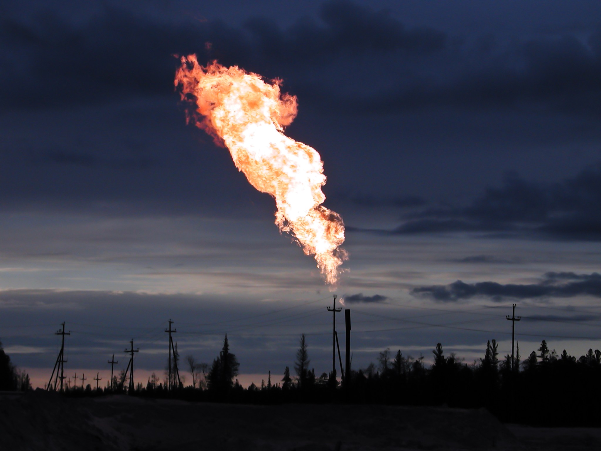
5 min read NASA Mission Excels at Spotting Greenhouse Gas Emission Sources Flaring, in which excess natural gas is intentionally burned into the air, is one way methane is released from oil and gas facilities. NASA’s EMIT mission, in more than a year in operation, has shown a proficiency at spotting emissions of methane and other greenhouse gases from space. Adobe Stock/Ilya Glovatskiy Since launching 16 months ago, the EMIT imaging spectrometer aboard the International Space Station has shown an ability to detect more than just surface minerals. More than…
Read MoreRecord-breaking ‘BOAT’ gamma-ray burst continues to amaze scientists
Last year, on Oct. 9, scientists witnessed an anomaly in the sky. Sprouting from the darkness between stars, an abundance of deep space X-rays started to flood observatories. These signals appeared to be connected to an immensely bright event happening in our galaxy known as a gamma-ray burst (GRB) — an outpouring of highly energetic particles linked to things like star explosions and black hole births. But as one expert said, for instance, this GRB is to a standard one what a floodlight is to a lightbulb. The event was…
Read MoreTrailblazing New Earth Satellite Put to Test in Preparation for Launch
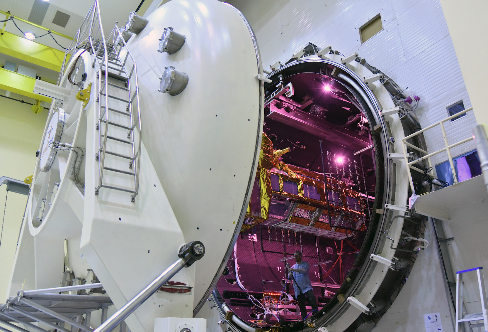
The NISAR satellite enters the thermal vacuum chamber at an ISRO facility in Bengaluru on Oct. 19. It emerged three weeks later having met all requirements of its performance under extreme temperatures and space-like vacuum. ISRO During three weeks in a thermal vacuum chamber in Bengaluru, India, the joint NASA-ISRO satellite demonstrated its hardiness in a harsh, space-like environment. NISAR, the trailblazing Earth-observing radar satellite being developed by the United States and Indian space agencies, passed a major milestone on Nov. 13, emerging from a 21-day test aimed at evaluating…
Read More