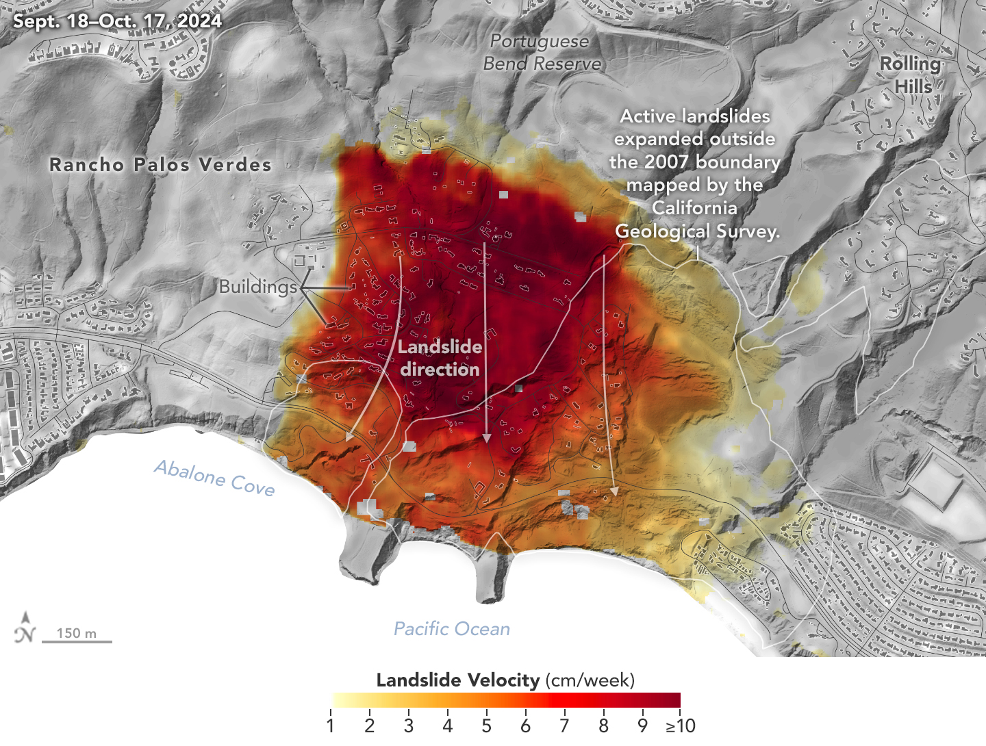
International SWOT Satellite Spots Planet-Rumbling Greenland Tsunami

4 min read Preparations for Next Moonwalk Simulations Underway (and Underwater) A SWOT data visualization shows water on the northern side of Greenland’s Dickson Fjord at higher levels than on the southern side on Sept. 17, 2023. A huge rockslide into the fjord the previous day led to a tsunami lasting nine days that caused seismic rumbling around the world. NASA Earth Observatory Data from space shows water tilting up toward the north side of the Dickson Fjord as it sloshed from south to north and back every 90 seconds…

Read More

A Particular Lenticular Cloud

New Zealand’s stunning scenery has famously provided the backdrop for fictional worlds in fantasy films. A unique cloud that forms over the Otago region of the country’s South Island also evokes the otherworldly, while very much existing in reality. NASA/Lauren Dauphin; USGS Landsat 8’s Operational Land Imager acquired this image of an elongated lenticular cloud, locally nicknamed the “Taieri Pet,” above New Zealand’s South Island on Sept. 7, 2024. Lenticular clouds form when prevailing winds encounter a topographic barrier, such as a mountain range. Wind that is forced to flow…

Read More

Before and after satellite images show lakes appearing across Sahara after deluge of rain soaks desert

Lakes have appeared in the Sahara after a cyclone brought a deluge of rain to northern Africa that drenched swathes of the largest hot desert on Earth, satellite images show. An extratropical cyclone hit parts of Morocco, Algeria, Tunisia and Libya on Sept. 7 and 8, dropping around 8 inches (20 centimeters) on the affected areas — equivalent to an entire year’s worth of rainfall in just a few days, according to NASA’s Earth Observatory. The deluge and runoff filled multiple ephemeral lakes in the Sahara, including the Sebkha el…

Read More

Satellite images capture Hurricane Milton intensifying into Category 5 storm (videos)

In the heart of the Gulf of Mexico, a new hurricane is brewing. Hurricane Milton, now having intensified into a Category 5 storm, was caught in incredible space-based imagery from spacecraft such as the U.S. National Oceanic and Atmospheric Administration’s GOES-East satellite.  Hurricane Milton comes just ten days after Hurricane Helene, the deadliest hurricane to hit the United States since Katrina, made landfall in the southeastern U.S.  Milton poses a solid threat to the regions it will impact, and the National Hurricane Center is urging residents of Florida to take…

Read More

Sunglint on the Alabama River

An astronaut aboard the International Space Station shot this photo of large meanders of the Alabama River while orbiting over the southern United States. The river’s smooth water surface reflects sunlight back toward the astronaut’s camera, producing an optical phenomenon known as sunglint. NASA/Woody Hoburg In this June 26, 2023, photo taken from the International Space Station, sunlight shines off the smooth waters of the Alabama River in a phenomenon known as sunglint. When photographing Earth, astronauts often take advantage of sunglint’s tendency to increase the contrast between water surfaces…

Read More

NASA Data Helps Protect US Embassy Staff from Polluted Air

4 Min Read NASA Data Helps Protect US Embassy Staff from Polluted Air This visualization of aerosols shows dust (purple), smoke (red), and sea salt particles (blue) swirling across Earth’s atmosphere on Aug. 23, 2018, from NASA’s GEOS-FP (Goddard Earth Observing System forward processing) computer model. Credits: NASA’s Earth Observatory United States embassies and consulates, along with American citizens traveling and living abroad, now have a powerful tool to protect against polluted air, thanks to a collaboration between NASA and the U.S. State Department. Since 2020, ZephAir has provided real-time…

Read More

Childhood Snow Days Transformed Linette Boisvert into a Sea Ice Scientist

Linette Boisvert turned a childhood love of snow into a career as a sea ice scientist studying climate change. Name: Linette BoisvertTitle: Assistant Lab Chief, Cryospheric Sciences Branch, and Deputy Project Scientist for the Aqua SatelliteFormal Job Classification: Sea Ice ScientistOrganization: Cryospheric Science Branch, Science Directorate (Code 615) “When it snowed, school was cancelled so I loved winter weather, and I was fascinated how weather could impact our daily lives,” said Linette. “One of my undergraduate classes had a guest lecturer talk about the Arctic and that is when decided that I…

Read More

NASA Selects Companies for Commercial SmallSat Services Award

Credit: NASA NASA has selected eight companies for a new award to help acquire Earth observation data and provide related services for the agency. The Commercial SmallSat Data Acquisition Program On-Ramp1 Multiple Award contract is a firm-fixed-price indefinite-delivery/indefinite-quantity multiple-award contract with a maximum value of $476 million, cumulatively amongst all the selected contractors, and a performance period through Nov. 15, 2028. The selectees are: BlackSky Geospatial Solutions, Inc. in Herndon, Virginia ICEYE US Inc. in Irvine, California MDA Geospatial Service Inc. in Richmond, British Columbia, Canada Pixxel Space Technologies, Inc…

Read More

NASA Earth Scientists Take Flight, Set Sail to Verify PACE Satellite Data

5 min read Preparations for Next Moonwalk Simulations Underway (and Underwater) More than 100 scientists will participate in a field campaign involving a research vessel and two aircraft this month to verify the accuracy of data collected by NASA’s new PACE satellite: the Plankton, Aerosol, Cloud, ocean Ecosystem mission. The process of data validation includes researchers comparing PACE data with data collected by similar, Earth-based instruments to ensure the measurements match up. Since the mission’s Feb. 8, 2024 launch, scientists around the world have successfully completed several data validation campaigns; the…

Read More