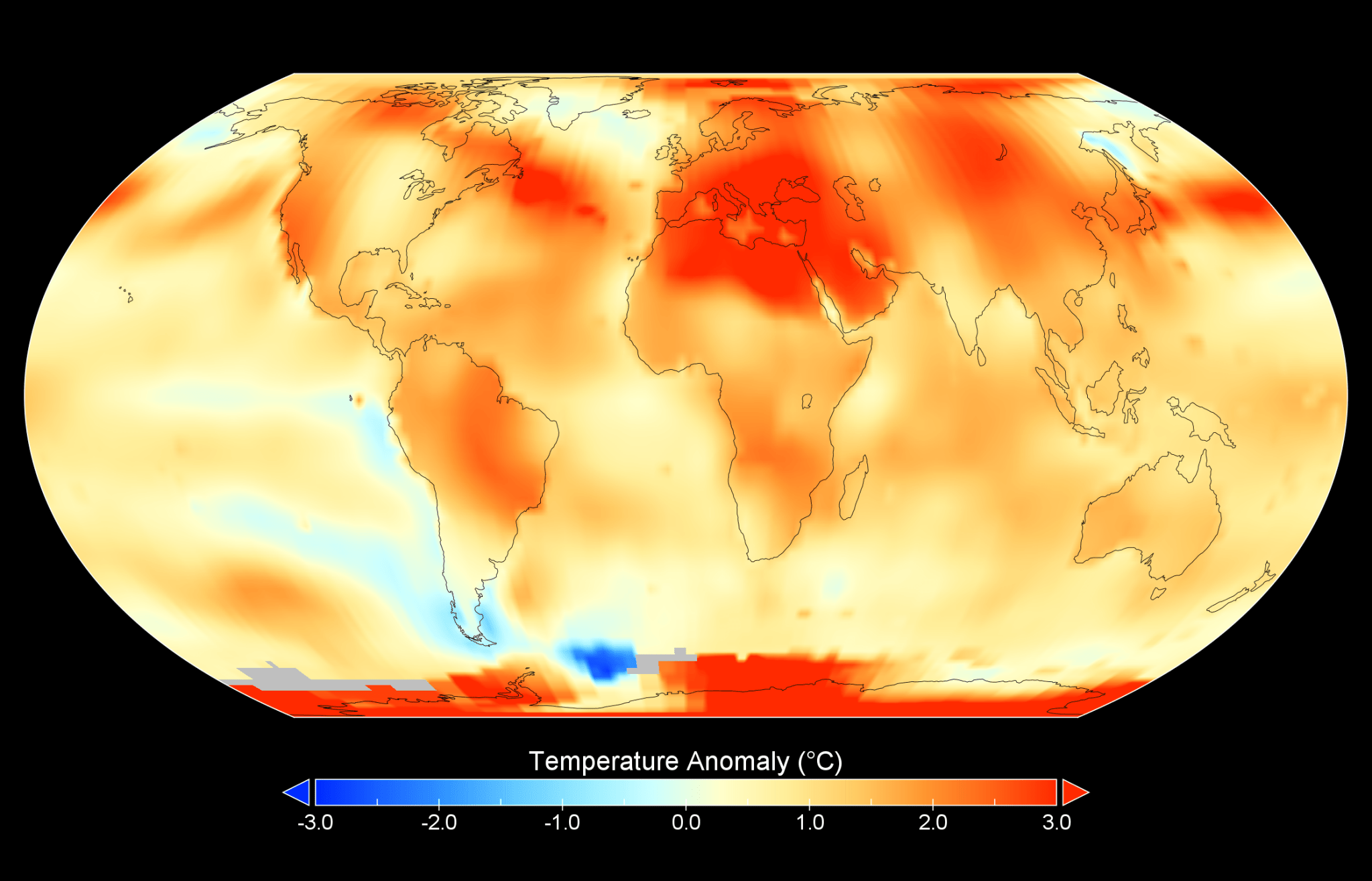
Proyecto de la NASA en Puerto Rico capacita a estudiantes en biología marina

9 Min Read Proyecto de la NASA en Puerto Rico capacita a estudiantes en biología marina Una península cubierta por un bosque verde en la isla de Culebra se adentra en las aguas azules del Caribe mientras una tormenta cae a lo lejos. El azul turquesa que rodea la isla indica la presencia de aguas poco profundas, que son el hogar de los famosos arrecifes de coral de esta isla. Credits: Centro Ames de la NASA/Milan Loiacono Read this story in English here. Tainaliz Marie Rodríguez Lugo respiró hondo, se ajustó…

Read More

Weird mystery waves that baffle scientists may be ‘everywhere’ inside Earth’s mantle

Mysterious zones in the deep mantle where earthquake waves slow to a crawl may actually be everywhere, new research finds. Scientists already knew that ultra-low velocity zones (ULVZs), hover near hotspots — regions of the mantle where hot rock moves upward, forming volcanic island chains such as Hawaii. But mysterious earthquake waves suggest that these features might be widespread. ULVZs, which are located in the lower mantle near the core-mantle boundary, can slow seismic waves by up to 50%. That’s remarkable, said Michael Thorne, a geologist and geophysicist at the University of Utah.…

Read More

NASA Project in Puerto Rico Trains Students in Marine Biology

7 Min Read NASA Project in Puerto Rico Trains Students in Marine Biology A forested green peninsula of Culebra Island juts into the blue waters of the Caribbean as a rain storm hits in the distance. The teal blue surrounding the island indicates shallow waters, home to the island's famous coral reefs. Credits: NASA Ames/Milan Loiacono Tainaliz Marie Rodríguez Lugo took a deep breath, adjusted her snorkel mask, and plunged into the ocean, fins first. Three weeks earlier, Rodríguez Lugo couldn’t swim. Now the college student was gathering data on…

Read More

NASA-Designed Greenhouse Gas-Detection Instrument Launches

This artist’s concept depicts one of the Carbon Mapper Coalition’s Tanager satellites, the first of which launched on Aug. 16. Tanager-1 will use imaging spectrometer technology developed at JPL to measure greenhouse gas point-source emissions. Planet Labs PBC Developed by the agency’s Jet Propulsion Laboratory, the imaging spectrometer will provide actionable data to help reduce emissions that contribute to global warming. Tanager-1, the Carbon Mapper Coalition’s first satellite, which carries a state-of-the-art, NASA-designed greenhouse-gas-tracking instrument, is in Earth orbit after lifting off aboard a SpaceX Falcon 9 rocket from Space…

Read More

São Francisco’s Colorful Palette

NASA This Dec. 27, 2023 image of the São Francisco River in southeast Brazil showcases the range of vibrant colors in the area including blues, reds, greens, and yellows. Much of the unvegetated land, such as unplanted fields and unpaved roads, appears in bright shades of red and yellow. This coloration comes from the underlying clays and soils of Brazil’s state of Minas Gerais. The photo focuses on the Três Marias Reservoir, a human-made waterbody fed by the São Francisco River. Access to freshwater for irrigation enables agriculture around the reservoir.…

Read More

NASA satellite data adds key pollutant to national environmental justice database

Scientists harnessed satellite technology to track a key air pollutant previously absent from a national database, NASA announced earlier this week, marking a crucial step forward in monitoring differences in air quality across the U.S. and identifying groups whose health is unfairly affected. Measurements of nitrogen dioxide, which is primarily released into air through the burning of fossil fuels and can lead to respiratory diseases like asthma among other health problems, had been missing from the Environmental Justice Screening and Mapping Tool, or EJScreen. The database is maintained by the…

Read More

Tundra Vegetation to Grow Taller, Greener Through 2100, NASA Study Finds

4 min read Preparations for Next Moonwalk Simulations Underway (and Underwater) Warming global climate is changing the vegetation structure of forests in the far north. It’s a trend that will continue at least through the end of this century, according to NASA researchers. The change in forest structure could absorb more of the greenhouse gas carbon dioxide (CO2) from the atmosphere, or increase permafrost thawing, resulting in the release of ancient carbon. Millions of data points from the Ice, Cloud, and land Elevation Satellite 2 (ICESat-2) and Landsat missions helped…

Read More

Telfer Mine, Western Australia

NASA/Michala Garrison, USGS Landsat 9’s Operational Land Imager-2 captured this image of the open pits and ponds of Telfer Mine and the surrounding rust-colored soil on Dec. 15, 2023. The soils have a reddish tint from the iron oxides that have accumulated from millions of years of weathering. This part of Western Australia is known for being rich in natural resources, including petroleum, iron ore, copper, and certain precious metals. Beneath the soils, veins of gold and silver run through sedimentary rocks, such as quartz sandstone and siltstone, that formed about 600 million years ago,…

Read More

Earth’s plate tectonics fired up hundreds of millions of years earlier than we thought, ancient crystals reveal

The plate tectonics that cause earthquakes, build mountains and split continents may have started when Earth was in its infancy, new research finds — significantly earlier than many scientists previously thought.  The new study suggests plate tectonics started more than 4 billion years ago — not long after the planet formed 4.5 billion years ago. In this era, known as the Hadean, Earth was fresh and piping hot, with an ammonia-and-methane atmosphere imbued with enough water to eventually condense into a planet-wide ocean. During this period, Earth cooled enough to…

Read More

NASA Returns to Arctic Studying Summer Sea Ice Melt

5 Min Read NASA Returns to Arctic Studying Summer Sea Ice Melt NASA's Gulfstream III aircraft taxis on the runway at Pituffik Space Base as it begins one of its daily science flights for the ARCSIX mission. Credits: NASA/Gary Banziger What happens in the Arctic doesn’t stay in the Arctic, and a new NASA mission is helping improve data modeling and increasing our understanding of Earth’s rapidly changing climate. Changing ice, ocean, and atmospheric conditions in the northernmost part of Earth have a large impact on the entire planet. That’s…

Read More