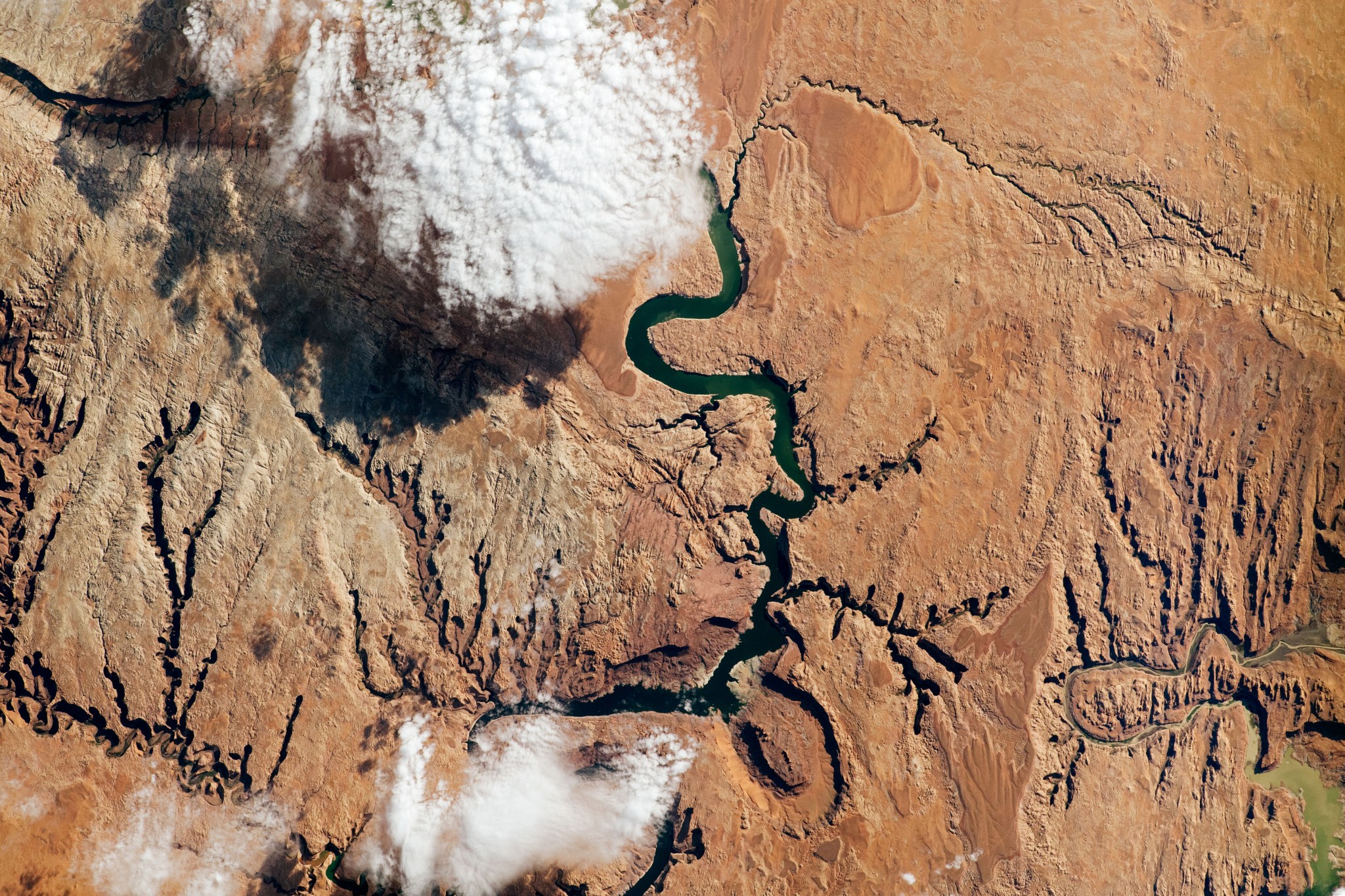
AI for Earth: How NASA’s Artificial Intelligence and Open Science Efforts Combat Climate Change

4 min read AI for Earth: How NASA’s Artificial Intelligence and Open Science Efforts Combat Climate Change Lights brighten the night sky in this image of Europe, including Poland, taken from the International Space Station. NASA As extreme weather events increase around the world due to climate change, the need for further research into our warming planet has increased as well. For NASA, climate research involves not only conducting studies of these events, but also empowering outside researchers to do the same. The artificial intelligence (AI) efforts spearheaded by the…

Read More

SWOT Satellite Helps Gauge the Depth of Death Valley’s Temporary Lake

Water depths in Death Valley’s temporary lake ranged between about 3 feet (or 1 meter, shown in dark blue) to less than 1.5 feet (0.5 meters, light yellow) from February through early March. By measuring water levels from space, SWOT enabled research to calculate the depth. NASA/JPL-Caltech Data from the international Surface Water and Ocean Topography mission helped researchers to calculate the depth of water in this transient freshwater body. California’s Death Valley, the driest place in North America, has hosted an ephemeral lake since late 2023. A NASA-led analysis…

Read More

NASA’s PACE Data on Ocean, Atmosphere, Climate Now Available

4 min read Preparations for Next Moonwalk Simulations Underway (and Underwater) NASA’s PACE satellite’s Ocean Color Instrument (OCI) detects light across a hyperspectral range, which gives scientists new information to differentiate communities of phytoplankton – a unique ability of NASA’s newest Earth-observing satellite. This first image released from OCI identifies two different communities of these microscopic marine organisms in the ocean off the coast of South Africa on Feb. 28, 2024. The central panel of this image shows Synechococcus in pink and picoeukaryotes in green. The left panel of this…

Read More

New NASA Strategy Envisions Sustainable Future for Space Operations

Low Earth orbit, the focus of volume one of NASA’s Space Sustainability Strategy, is the most concentrated area for orbital debris. This computer-generated image showcases objects that are currently being tracked.  Credits: NASA ODPO To address a rapidly changing space operating environment and ensure its preservation for generations to come, NASA released the first part of its integrated Space Sustainability Strategy, on Tuesday advancing the agency’s role as a global leader on this crucial issue. “The release of this strategy marks true progress for NASA on space sustainability,” said NASA…

Read More

Chinese space junk falls to Earth over Southern California, creating spectacular fireball (photos, video)

A big piece of Chinese space junk crashed to Earth over Southern California early Tuesday morning (April 2), putting on quite a show for observers in the Golden State. The fall created a blazing fireball witnessed by people from the Sacramento area all the way down to San Diego, according to the American Meteor Society (AMS). As of Tuesday afternoon, 81 people had reported sightings of the event to the AMS.  The hunk of space debris was the orbital module of China’s Shenzhou 15 spacecraft, according to astrophysicist and satellite…

Read More

Satellites watch Iceland volcano spew gigantic plume of toxic gas across Europe

Scientists are tracking a massive plume of toxic gas moving across northern Europe that was spat out by the ongoing volcanic eruption in Iceland. The gas cloud is unlikely to cause any serious health problems. However, it could impact the ozone hole above the Arctic, experts warn. On March 16, an underground volcano in Icealnd’s Reykjanes Peninsula blew its top for the fourth time in as many months, opening up the largest fissure of the current eruption cycle and unleashing a massive lava flow that narrowly missed the evacuated town of Grindavík. There…

Read More

Sleeping subduction zone could awaken and form a new ‘Ring of Fire’ that swallows the Atlantic Ocean

A subduction zone below the Gibraltar Strait is creeping westward and could one day “invade” the Atlantic Ocean, causing the ocean to slowly close up, new research suggests. The subduction zone, also known as the Gibraltar arc or trench, currently sits in a narrow ocean corridor between Portugal and Morocco. Its westward migration began around 30 million years ago, when a subduction zone formed along the northern coast of what is now the Mediterranean Sea, but it has stalled in the last 5 million years, prompting some scientists to question whether…

Read More

SWOT Satellite Catches Coastal Flooding During California Storms

4 min read Preparations for Next Moonwalk Simulations Underway (and Underwater) This image shows SWOT satellite data for water surface height in part of Mendocino County, Northern California, on Jan. 15, before several atmospheric rivers arrived, and on Feb. 4, after the first storms. Light blue and green indicate the highest water levels relative to mean sea level. (Inland water heights include the underlying ground elevation.) NASA/JPL-Caltech Operated by NASA and the French space agency, the Surface Water and Ocean Topography mission provides a new view of water on land,…

Read More

SpaceX rocket launches pioneering methane-tracking satellite to orbit

A new satellite that will track climate-heating methane emissions from oil and gas companies around the world launched this week from California’s Vandenberg Space Force Base.  The washing-machine-sized satellite, named MethaneSAT, lifted off Monday (March 4) atop a Falcon 9 rocket, one of 53 payloads on SpaceX’s Transporter-10 rideshare mission. MethaneSAT is designed to ultimately help policymakers independently verify industry reports by pinpointing hotspots of methane, the invisible but potent greenhouse gas, which traps much more heat in Earth’s atmosphere per molecule than carbon dioxide. MethaneSAT, the first satellite by…

Read More

Can Volcanic Super Eruptions Lead to Major Cooling? Study Suggests No

Some 74,000 years ago, the Toba volcano in Indonesia exploded with a force 1,000 times more powerful than the 1980 eruption of Mount St. Helens. The mystery is what happened after that – namely, to what degree that extreme explosion might have cooled global temperatures. Crew aboard the International Space Station photographed the eruption of Mount Etna in Sicily in October 2002. Ashfall was reported more than 350 miles away. When it comes to explosive power, however, no eruption in modern times can compare with a super eruption – which…

Read More