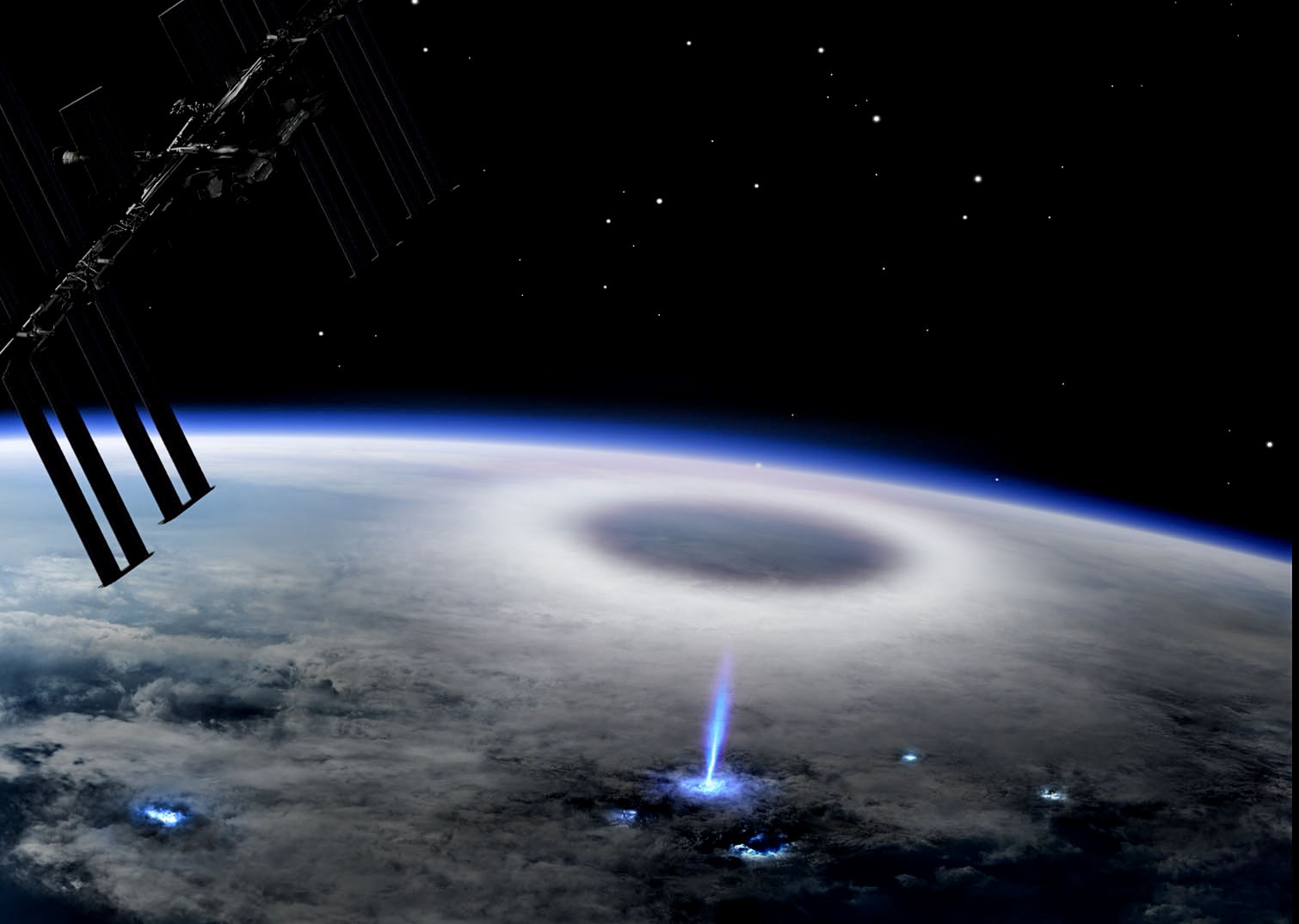
NASA Tracks Snowmelt to Improve Water Management

3 min read Preparations for Next Moonwalk Simulations Underway (and Underwater) The C-20A aircraft, based at NASA’s Armstrong Flight Research Center in Edwards, California, flies over the Sierra Nevada Mountains in California for the Dense UAVSAR Snow Time (DUST) mission on Feb. 28, 2025. The DUST mission collected airborne data about snow water to help improve water management and reservoir systems on the ground. NASA/Starr Ginn As part of a science mission tracking one of Earth’s most precious resources – water – NASA’s C-20A aircraft conducted a series of seven…

Read More

Testing in the Clouds: NASA Flies to Improve Satellite Data

3 min read Preparations for Next Moonwalk Simulations Underway (and Underwater) Piloted by NASA’s Tim Williams, the ER-2 science aircraft ascends for one of the final science flights for the GSFC Lidar Observation and Validation Experiment (GLOVE) on Feb. 1, 2025. As a collaboration between engineers, scientists, and aircraft professionals, GLOVE aims to improve satellite data products for Earth Science applications. NASA/Steve Freeman In February, NASA’s ER-2 science aircraft flew instruments designed to improve satellite data products and Earth science observations. From data collection to processing, satellite systems continue to…

Read More

NASA Measures Moonlight to Improve Earth Observations

The airborne Lunar Spectral Irradiance (air-LUSI) instrument is moved across the hangar floor by robotic engineer Alexander McCafferty-Leroux ,from right to left, co-investigator Dr. John Woodward, NIST astronomer Dr. Susana Deustua, air-LUSI chief system engineer Dr. Kathleen “Kat” Scanlon, and members of the ER-2 ground crew at NASA’s Armstrong Flight Research Center in Edwards, California, in March 2025. NASA/Genaro Vavuris Flying high above the clouds and moon-gazing may sound like a scene from a timeless romance, but NASA did just that in the name of Earth science research. In March…

Read More

NASA Researchers Study Coastal Wetlands, Champions of Carbon Capture

Earth (ESD) Earth Explore Explore Earth Science Climate Change Air Quality Science in Action Multimedia Image Collections Videos Data For Researchers About Us 8 Min Read NASA Researchers Study Coastal Wetlands, Champions of Carbon Capture Florida’s coastal wetlands are a complex patchwork of ecosystem — consisting of sawgrass marshland, hardwood hammocks, freshwater swamps, and mangrove forests. Credits: NASA/ Nathan Marder Across the street from the Flamingo Visitor’s Center at the foot of Florida’s Everglades National Park, there was once a thriving mangrove population — part of the largest stand of…

Read More

NASA Uses New Technology to Understand California Wildfires

3 min read Preparations for Next Moonwalk Simulations Underway (and Underwater) The Compact Fire Infrared Radiance Spectral tracker, or C-FIRST, is managed an operated by NASA’s Jet Propulsion Laboratory, and supported by NASA’s Earth Science Technology Office. Combining state-of-the-art imaging technology with a compact design, C-FIRST enables scientists to gather data about fires and their impacts on ecosystems with greater accuracy and speed than other instruments. C-FIRST was developed as a spaceborne instrument, and flew onboard NASA’s B200 aircraft in January 2025 to conduct an airborne test. NASA/JPL-Caltech The January…

Read More

High-Altitude ER-2 Flights Get Down-to-Earth Data

3 min read Preparations for Next Moonwalk Simulations Underway (and Underwater) Francisco Rodriguez (aircraft mechanic) services liquid oxygen or LOX on the ER-2 during the Geological Earth Mapping Experiment (GEMx) research project. Experts like Rodriguez sustain a high standard of safety on airborne science aircraft like the ER-2 and science missions like GEMx. The ER-2 is based out of NASA’s Armstrong Flight Research Center in Edwards, California. NASA/Steve Freeman Operating at altitudes above 99% of the Earth’s atmosphere, NASA’s ER-2 aircraft is the agency’s highest-flying airborne science platform. With its…

Read More

NASA Data Helps Protect US Embassy Staff from Polluted Air

4 Min Read NASA Data Helps Protect US Embassy Staff from Polluted Air This visualization of aerosols shows dust (purple), smoke (red), and sea salt particles (blue) swirling across Earth’s atmosphere on Aug. 23, 2018, from NASA’s GEOS-FP (Goddard Earth Observing System forward processing) computer model. Credits: NASA’s Earth Observatory United States embassies and consulates, along with American citizens traveling and living abroad, now have a powerful tool to protect against polluted air, thanks to a collaboration between NASA and the U.S. State Department. Since 2020, ZephAir has provided real-time…

Read More

Meet NASA Women Behind World’s Largest Flying Laboratory

5 min read Preparations for Next Moonwalk Simulations Underway (and Underwater) NASA’s DC-8 aircraft – the world’s largest flying science laboratory – began its science missions in 1987 and since then, has flown in service of the science community over places like Antarctica, Greenland, and Thailand. Aircraft like the DC-8 have enabled scientists to ask questions about life on Earth and explore them in a way that only NASA’s Airborne Science program can make happen. After 37 years, the DC-8 will retire to Idaho State University, where it will serve…

Read More

Can Volcanic Super Eruptions Lead to Major Cooling? Study Suggests No

Some 74,000 years ago, the Toba volcano in Indonesia exploded with a force 1,000 times more powerful than the 1980 eruption of Mount St. Helens. The mystery is what happened after that – namely, to what degree that extreme explosion might have cooled global temperatures. Crew aboard the International Space Station photographed the eruption of Mount Etna in Sicily in October 2002. Ashfall was reported more than 350 miles away. When it comes to explosive power, however, no eruption in modern times can compare with a super eruption – which…

Read More